Counties of Ireland
The counties of Ireland are land divisions, originally formed following the Norman invasion. Between the late 1190s and 1607, the island of Ireland was divided by the historic Kingdom of Ireland into thirty-two counties (Irish: contae or condae IPA: [ˈkʊndeː]).[1]
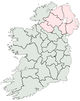
Under the Government of Ireland Act 1920, "Home Rule" institutions were created in two divisions of Ireland, 26 counties forming Southern Ireland and six counties forming Northern Ireland. This partition was copperfastened by the 1922 Anglo-Irish Treaty, under which Ireland left the United Kingdom, Northern Ireland rejoining two days later. Southern Ireland, which had never functioned as a separate entity, became the Irish Free State, now the Republic of Ireland.
The counties of Northern Ireland are no longer used for local government, and two former counties in the Republic have been subdivided, giving a modern total of twenty-nine counties for administrative purposes rather than twenty-six. The names "County Dublin" and "County Tipperary" remain in common usage outside administrative matters. In addition, the larger cities are administratively equivalent to counties. See Local government in the Republic of Ireland.
The traditional thirty-two counties had previously been adopted by sporting and cultural organisations such as the Gaelic Athletic Association, which organises its activities on GAA county lines, and today they still attract strong loyalties, particularly in the sporting field.
In Ireland, the usage of the word county nearly always comes before rather than after the county name; thus "County Clare" in Ireland as opposed to "Clare County" in Michigan, U.S.A. The former "King's County" and "Queen's County" were exceptions; these are now County Offaly and County Laois. The abbreviation Co. is used, as in "Co. Clare". The synonym shire is not used for Irish counties, although the Marquessate of Downshire was named in 1789 after County Down.
Contents |
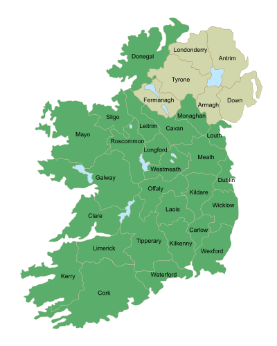
Map of traditional counties
These do not correspond exactly to the counties used as political units. The map links to articles by using the above image map. Click on a county to go to the corresponding article. Note: Northern Ireland counties are colored tan; Londonderry is often called Derry: see Derry-Londonderry name dispute.
Historical evolution
The political geography of Ireland can be traced with some accuracy from the seventh century. At that time Ireland was divided into about one hundred and fifty different units of government, each one called a tuath (pl. tuatha). A tuath was an autonomous group of people of independent political jurisdiction under a chief called sub-rege (Rí Tuaithe, tribal king - often the chief of a clan).[2]
Cúigí (Provinces)
In the sixth century, Ireland was divided into cúigí or fifths (sing. cúige). The four current provinces of Ireland were named for, and reflect the broad shape of, four of these cúigí, Ulaidh (Ulster), Laighin (Leinster), Connachta (Connacht) and An Mhumha(ain) (Munster). The fifth cúige, Mídhe (Mide), corresponded to the present-day counties of Meath, Westmeath, Longford, Offaly and south County Louth, whilst north County Louth was considered to be part of Ulster, however after 1596 the entire county has been a part of Leinster. In bardic lore, the "fifths of Ireland" corresponded to the five provinces: learning was in the west, war in the north, wealth in the east, music or art in the south and kingship in the centre (Meath).
Shiring and Counties
|
Life in Ireland |
|---|
|
Culture
Economy
General
Society
Politics
Policies
|
In 1172, Henry II arrived in Dublin, commencing English royal involvement [3] in Ireland (along with the arrival of the Cambro-Norman knights, commonly referred to in Ireland as the Norman Invasion). The English governed Ireland in a like structure as they did themselves, by dividing the country into shires or counties in the late 12th and early 13th centuries.
The counties were made up, in general, from an amalgamation of various smaller Irish territories which suited the colonial administration at the time and had little basis in older tribal boundaries. In many cases this involved dividing an Irish territory in two. For example, the kingdom of Uí Maine was split to form south County Roscommon and most of east County Galway. Many of the counties of Ulster roughly correspond to the territories controlled by the principal clan in that particular area such as the O Donnells of Tír Conaill whose political power was concentrated in what would become the County of Donegal.
First divisions
The counties evolved over time, with the earliest defined being set out by King John, including a then much larger County Dublin. By 1200 there were also shires of Connacht, Cork, Kerry, Limerick, Louth and Tipperary. Waterford, Kilkenny and Wexford apparently date from this time, too, as remnants of Strongbow's palatine county in Leinster. The process continued over time, and in 1206, for example, a special commission was used to determine borders in the Munster area.
The County of Roscommon was separated from Connacht before 1292, and the first session of the Irish parliament in 1297 created the new shires of County Kildare, Meath and Ulster. Carlow, then larger than today, and extending to and including coastal Arklow, probably dates from around 1306.[4]
In the 14th century, "Counties of the Cross" emerged, consisting of scattered areas of church land within the existing divisions. Unlike the secular counties (or liberties), the counties of the cross were administered by royally-appointed sheriffs.
The Tudors
The Tudor administrations finalised the division of Ireland into counties. Westmeath was separated from Meath (often East Meath) in 1543, and in 1556 King’s County and Queen’s County were created as part of Queen Mary's policy of Plantation. The old shire of Connacht was broken up into the counties of Galway, Mayo and Sligo, while Leitrim was separated from Roscommon in 1565. At the same time County Clare was created and moved from Munster to Connacht, being returned to Munster in 1602.
In 1583 County Longford was formed from part of Westmeath and transferred to the Province of Connacht.[5]
The Province of Ulster was the last to be shired. The counties of Antrim and Down originated early in the sixteenth century. These were joined in 1584/5 by the Counties of Armagh, Coleraine (later reformed as Londonderry), Donegal, Fermanagh, Monaghan and Tyrone. County Cavan was also formed in 1584 and transferred from Connacht to Ulster.[4]
Last county
The last county to be formed was County Wicklow in 1606-1607, taking in the southern part of Dublin (with the exception of three "islands," exclaves of (mainly) church property), and the northern part of "Catherlough" or Carlow, including Arklow.
One system
Regional presidencies of Connacht and Munster remained in existence until 1672, with special powers over their subsidiary counties. Tipperary remained a palatinate until 1716, with different officials and procedures from other counties. At the same time, Dublin, until the 19th century, had ecclesiatical liberties with rules outside those applying to the rest of Dublin city and county.
In addition, some functions later held by county authorities were exercised by Church of Ireland parishes, feudal structures of major old estates, and urban corporations under individual charters. Management was performed by grand juries, manned by the larger ratepayers in a county, who were inevitably the largest landowners.
By the late 19th century, all such anomalies were gone, and a single administrative system existed (see below).
Enclaves and exclaves
Aside from the Dublin enclaves between Kildare and Wicklow, at least eight other enclaves of one county inside another, or between two others, existed. The various enclaves and exclaves were merged into neighbouring and surrounding counties, primarily in the mid-19th century under a series of Orders in Council.
Evolution of functions
The counties were initially used for judicial purposes, but began to take on some governmental functions in the 17th century, notably with grand juries, composed of significant freeholding landowners and historically holding judicial functions, taking maintenance roles in regard to roads and bridges, and the collection of "county cess" taxes. In 1836, their use as local government units was further developed, with grand-jury powers extended under the Grand Jury (Ireland) Act 1836. In 1838, the number of administrative counties was increased to thirty-three when Tipperary was divided into North and South Ridings, and also in that year, local poor law boards, with a mix of magistrates and elected "guardians" took over the health and social welfare functions of the grand juries.
The Local Government (Ireland) Act 1898 introduced elected county councils taking over the powers of the grand juries.
Former counties
Former counties include: County Coleraine, which formed the basis of County Londonderry, the counties of Nether and Upper Tyrone,[6] and Desmond which was, in 1606, split between counties Cork and Kerry. Other names seen on old maps include Caterlaugh or Caterlagh, archaic designations of County Carlow, in the days before much of the north of that county was taken into Wicklow in the early 1600s.
The Earldom of Ulster consisted not only the counties of Antrim and Down, but also at different times the former counties of; del Art (Ards), Blathewyc (Newtownards), Carrickfergus, Ladcathel (Lecale), and Twescard.[7] Carrickfergus would loose its county town status in 1777. Twescard is preserved as the name of a school house at Campbell College, Belfast.
Administrative division of counties
County Tipperary was split into North and South Ridings in 1838. In 1994, County Dublin was split into Dun Laoghaire-Rathdown, Fingal, and South Dublin.
Boundary changes
The boundaries of the traditional counties have not always remained the same, changing on a number of occasions. As a result of the Local Government (Ireland) Act 1898 changes were made to the boundaries of Counties Galway, Clare, Mayo, Sligo, Waterford, Kilkenny, Meath and Louth, and others.[8] [9] [10] Under the Local Government Provisional Order Confirmation Act 1976, part of the urban area of Drogheda, which lay in County Meath, was transferred to County Louth on 1 January 1977. This resulted in the land area of County Louth increasing slightly at the expense of County Meath.[11] The possibility of a similar action with regard to Waterford City has been raised in recent years, though opposition from Kilkenny has been strong.
Subdivisions
To correspond with the subdivisions of the English shires into honors or baronies, Irish counties were granted out to the Anglo-Norman noblemen in cantreds, later known as baronies, which in turn were subdivided, as in England, into civil parishes and townlands. However, in many cases, these divisions correspond to earlier, pre-Norman, divisions. While there are 331 baronies in Ireland, and more than a thousand civil parishes, there are around sixty thousand townlands that range in size from one to several thousand hectares. Townlands were often traditionally divided into smaller units called quarters, but these subdivisions are not legally defined.
The counties today
Republic of Ireland
| Republic of Ireland |
 This article is part of the series: |
|
|
|
Constitution
Government
Judiciary
Elections
Divisions
Foreign policy
|
|
Other countries · Atlas |
The traditional twenty-six counties are today only part of the basis for local government, planning and community development purposes, although unlike the counties of the United Kingdom, the Republic's traditional county boundaries are still generally respected for other purposes (counties on occasion being sub-divided). The administrative borders have subsequently been altered to include various towns originally split between two counties wholly within one.
In the Republic of Ireland, six of the original twenty-six counties have more than one local authority area, producing a total of thirty-four "county-level" authorities. The two ridings of County Tipperary were renamed North Tipperary and South Tipperary in 2002. In 1994 County Dublin was split into Dun Laoghaire-Rathdown, Fingal, and South Dublin. By 2002 however, upon the establishment of County Development Boards, the definition of "local government" expanded to include the need for a proper identity in each of the new counties; the development of which is ongoing. Of the administrative structures established under the 1898 Local Government Act, the only type to have been completely abolished was the Rural District, which was rendered void in the early years of the Irish Free State amidst widespread allegations of corruption. On the other hand, administrative structures such as Town Councils and Regional Authorities (created to comply with requirements of the EU) exist in parallel with the county system.
Administration
Administration follows the thirty-four "county-level" counties and cities of Ireland. Of these twenty-nine are counties, governed by county councils while the five cities of Dublin, Cork, Limerick, Galway and Waterford have city councils (previously known as corporations) and are administered separately from the counties bearing those names. The City of Kilkenny is the only city in the republic which does not have a "city council"; it is still a borough but not a county borough and is administered as part of County Kilkenny. The most recent local government legislation states that Kilkenny may retain the title of "city" for ornament only.
Education
The Vocational Education Committee system was created in 1930. Originally, VECs were formed for each administrative county and county borough, and also in a number of larger towns. In 1997 the majority of town VECs were absorbed by the surrounding county. With the exception of the Dublin area, VEC areas are identical to the local government counties and cities. The separate committees for County Dublin and the former borough of Dún Laoghaire continue to exist.
The institute of technology system was organised on the committee areas or "functional areas", these still remain legal but are not as important as originally envisioned as the institutes are now more national in character and are only really applied today when selecting governing councils, similarly Dublin Institute of Technology was originally a group of several colleges of the City of Dublin committee.
Elections
Where possible, parliamentary constituencies in the Republic of Ireland follow county boundaries. Under the Electoral Act 1997 a Constituency Commission is established following the publication of census figures every five years. The Commission is charged with defining constituency boundaries, and the 1997 Act provides that the breaching of county boundaries shall be avoided as far as practicable.[12] This provision does not apply to the boundaries between cities and counties, or between the three counties in the Dublin area.
This system usually results in more populated counties having several constituencies: Dublin, including Dublin city, is subdivided into twelve constituencies, Cork into five. On the other hand, smaller counties such as Carlow and Kilkenny or Laois and Offaly may be paired to form constituencies. An extreme case is the splitting of Ireland's least populated county of Leitrim between the constituencies of Sligo-North Leitrim and Roscommon-South Leitrim.
Each county or city is divided into Local Electoral Areas for the election of councillors. The boundaries of the areas and the number of councillors assigned are fixed from time to time by order of the Minister for the Environment, Heritage and Local Government, following a report by the Local Government Commission, and based on population changes recorded in the census.[13]
Northern Ireland
In Northern Ireland, a major re-organisation of local government in 1973 replaced the six traditional counties and two county boroughs (Belfast and Derry) with twenty-six single-tier districts for local government purposes, and these cross the traditional county boundaries. The six counties and two county boroughs remain in use for some purposes, including Lord Lieutenants, vehicle number plates, and the Royal Mail postcode address file.
Alphabetical list
See also
References and footnotes
External links
Flags Baronies, Civil Parishes and Townlands
Representatives of local government
|
||||||||||||||||||||||||||||||||||||||||||||||||||||||||||||||||||||||||||||||||||||||||||||||||||||||||||||||||||||||||||||||||||||||||||||||||||||||||||||||||||||||||||||||||||||||||||||||||||||||||||||||||||||||||||||||||||||||||||||||||||||||||||||||||||||||||||||||||||||||||||||||||||||||